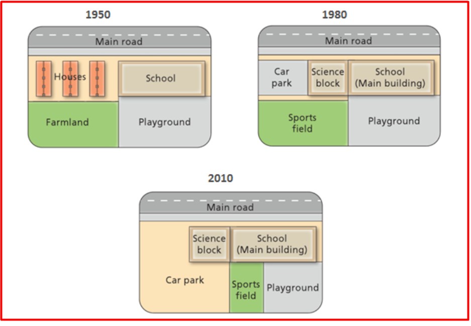
The pictures illustrate the changes, which have taken place at West Park secondary school from 1950 to 2010.
Firstly, significant alterations occurred to the farmland, it was redesigned to a sports field in 1980 and then to a car park in 2010. There was an expansion of the car park in 2010 and the sport field was placed between the car park and the playground.
Moreover, substantial changes happened to the houses. They were removed from the map, car park and science block taking their place.
Furthermore, a science block was added to the school building in 1980 and playground was reduced in size. However, the locations of the playground and school were not modified.
In contrast, the main road remained unchanged throughout the period.
Overall, farmland and houses disappeared from the map, playground was abridged, and there were built science block, car park and sports field.
Estimated band6.5
6.0
6.0
6.5
6.5
Response 02
189 words
The diagrams illustrate the alterations that have been effected at West Park Secondary school since it was constructed in 1950 to the year 2010. Overall, the location of the main road remained unchanged throughout the given years given. However, they were eradicated and replaced by different structures.
To begin, in 1950, the location of the main road was situated along the northern border of the layout, and this remained unchanged both in 1980 and 2010. Again, the residential site and farmland which used to be located on the left-hand side of the town were removed and replaced with a quite smaller car pack and a much bigger sports field found in the southwestern part of the town in 1980; meanwhile, in 2010, the already mentioned portion was substituted with a much larger car parking area featuring a much smaller sports field.
Additionally, the school building used to be much smaller in 1950 as compared to similar views in 1980 and 2010 with an extension that included the addition of a science block. The playground which was found in the south-east corner of the town still remained the same in 1950 and 1980, but with the 2010 plan, the size was somehow smaller.
Estimated band7.0
7.0
7.0
7.0
7.0
Response 03
141 words
The maps show the development of West Park Secondary School during a 60-year span, from 1950 to 2010.
As evidenced by the maps, the erection of a parking lot was clearly the most significant alteration at the school. In addition, houses and farmland had completely disappeared by 2010.
The school was fairly modest in 1950, and it was situated south of the major road. In the northwest corner, there were residential dwellings, but these were removed in 1980 to make way for a parking space and a science block. Farmland was also demolished and replaced with a sports field, while the southeast area’s playground remained.
Between 1980 and 2010, the car park was significantly expanded, and the sports field was forced to relocate to the east, reducing the size of the playground. Meanwhile, the school’s science block and main building remained its former position by the main road.
Estimated band7.0
7.0
7.0
7.0
7.0
Response 04
133 words
The maps illustrate the transformations of West Park Secondary School over a 60-year period from 1950 to 2010. The most notable change during this time was the construction of a parking lot. By 2010, the houses and farmland that were once present had been completely demolished.
In 1950, the school was relatively small and located south of the main road. Residential houses occupied the northwest corner, but these were removed by 1980 to make room for a parking lot and a science block. A sports field also replaced the farmland, while the playground in the southeast area stayed unchanged.
From 1980 to 2010, the parking lot was significantly expanded, causing the sports field to move eastward and reducing the playground’s size. Throughout these shifts, the school’s science block and main building remained in their original positions by the main road.
TA Task AchievementCC Coherence & CohesionLR Lexical ResourceGRA Grammatical Range & Accuracy
From essays on this question
Useful vocabulary
parking lot
Meaning
An area where people can leave their cars.
From the essay
The most notable change during this time was the construction of a parking lot.