
Overview
1 pointThe entire area is slated to undergo a comprehensive metamorphosis, transforming it into a residential district.
Find in essay
The maps below show an industrial area in the town of Norbiton, and planned future development of the site.
Summarise the information by selecting and reporting the main features, and make comparisons where relevant.
From essays on this question
WhyThis is aMap — it asks you to describe how a place changed.
SoWe split the points intoOverview(the overall change to the place)andKey changes(what was added, removed, moved or kept).
The entire area is slated to undergo a comprehensive metamorphosis, transforming it into a residential district.
The factories will be replaced by housing and facilities like shops and a medical centre, and a school will be constructed in the east, with a nearby park.
In the future, two new exits will be constructed at the roundabout, enabling passage towards the northwest and north directions, crossing over a newly built bridge that leads to new housing.
In the future, while the roundabout will persist, the factories will give way to commercial establishments, and new residential complexes will emerge alongside a north-western avenue.
To the north, a bridge will span the river, and some of the farmland will be supplanted with housing, albeit not to the east, where no alterations are planned.
Additionally, a new hospital will be constructed in the south-eastern district.
The existing eastward thoroughfare will be flanked by new residences and will feature a substantial playground to the north and a school at the easternmost boundary of the town.
Beyond the town centre, plans are underway to construct a small roundabout in the southern region that will bisect an existing street.
It is also interesting to know that the town lying in the western part of the town will remain unchanged in the future plan.
Same question · Different responses
Answer · 219 words · 3 paragraphs · 16 comments
Answer · 197 words · 4 paragraphs · 14 comments
Answer · 199 words · 3 paragraphs · 8 comments
Answer · 193 words · 3 paragraphs · 8 comments
From essays on this question
The factories will be replaced by housing and facilities like shops and a medical centre, and a school will be constructed in the east, with a nearby park.
Currently, the town centre comprises a central roundabout, surrounded by factories, and a west-to-east thoroughfare.
The farmland is situated to the north of the river, and a roundabout occupies the centre of the district, providing access to two exits.
Additionally, a small roundabout will be built on the main road to link to the larger roundabout.
To the north, a bridge will span the river, and some of the farmland will be supplanted with housing, albeit not to the east, where no alterations are planned.
From essays on this question
This transformation will chiefly take place in the western and northern regions of the town, with only a minuscule portion of farmland remaining untouched.
At present, the location lies to the east of Norbiton, with a river flowing from west to east in the northern sector.
One leads to a main road in the south, while the other is oriented towards the east, with factories dispersed on both sides of the roundabout.
Practise this question
You should spend about 20 minutes on this task. Write at least 150 words.
Related questions
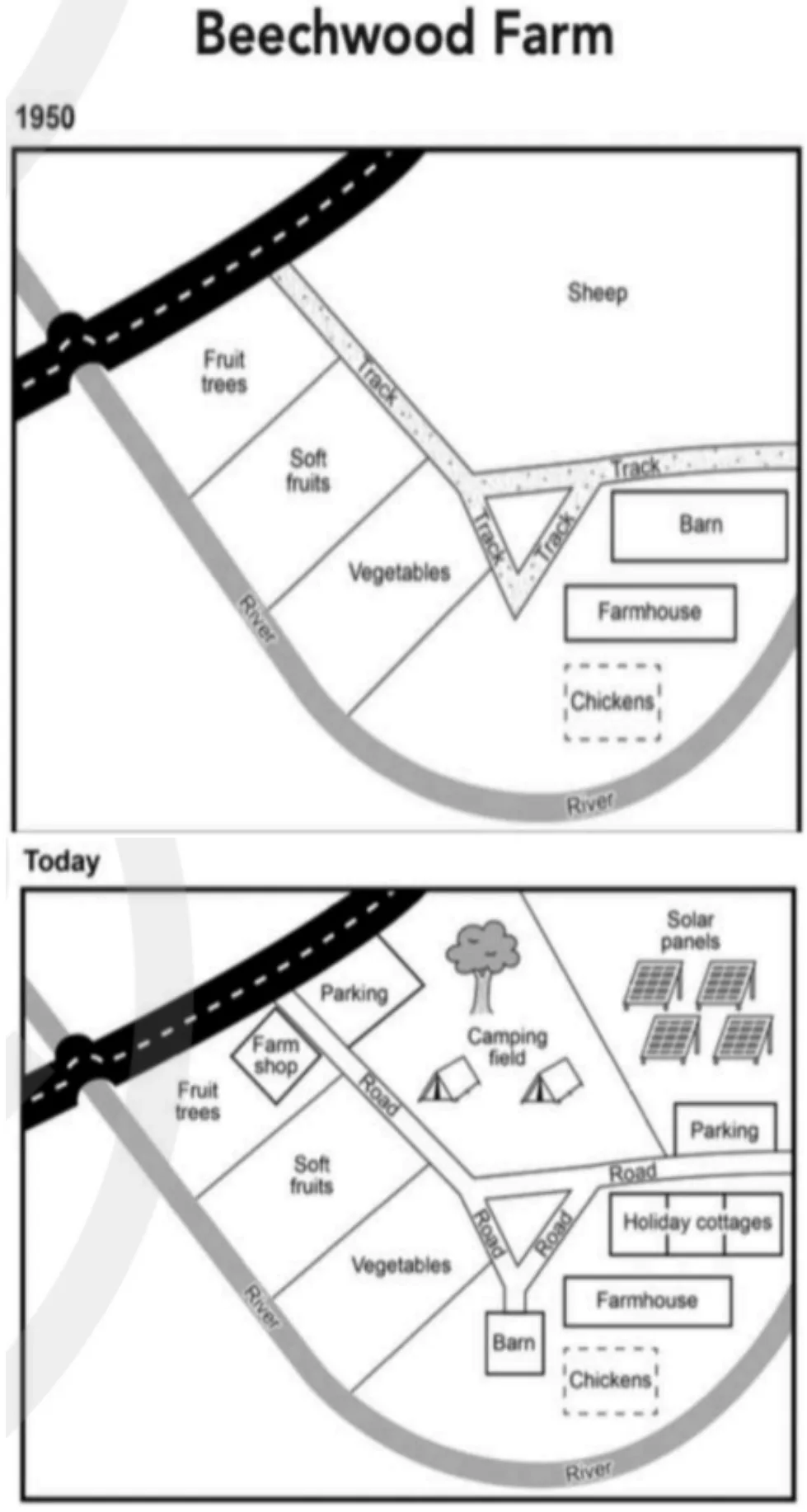
The plans below show the site of a farm in 1950 and the same site today. Summarise the information by selecting and reporting the main features, and make comparisons where relevant.
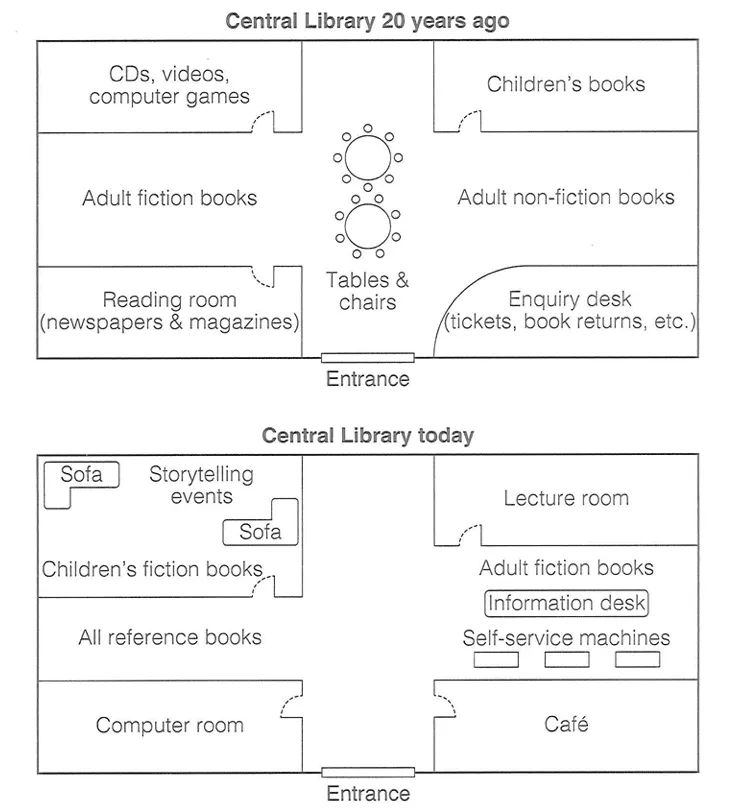
The diagram below shows the floor plan of a public library 20 years ago and how it looks now. Summarise the information by selecting and reporting the main features, and make comparisons where relevant.
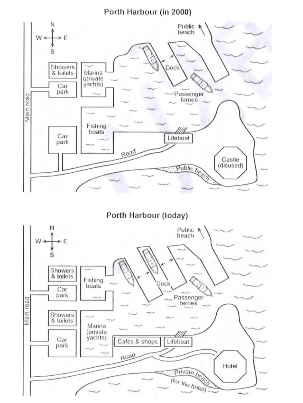
The plans below show a harbour in 2000 and how it looks today. Summarise the information by selecting and reporting the main features, and make comparisons where relevant.