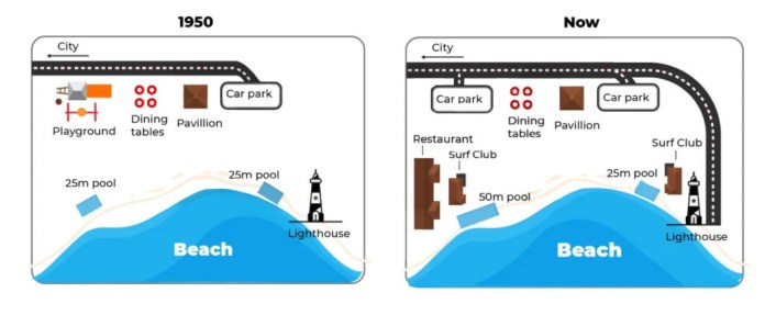
They yielded two maps that demonstrate a beachfront area in 1950 and presently in Australia.
Overall, the major changes are surrounding the beach where clubs and restaurants open now and the new road is made.
In 1950, a car parking road was connected to city road and alongside that road was round shape play ground and dining tables. There was two same dimensions pool, and one was on the east side while another was on the west side of the beach. The pool was 25 meters long. Additionally, one pavilion was between car parking and dining tables, a small lighthouse beside the east pool.
Currently, we can see dramatic changes, primarily in the road. Now the road is not ending at car parking. It developed to the lighthouse, and it’s in u shape. No change for dining tables and pavilion; however, small car parking takes the place of the playground. Another car park area is increased on the southwest side, pool dimensions double than 1950, and open restaurants. One new advancement surf club is the backside of 50m pool, and one is the 25m pool backside.
Estimated band7.0
7.0
7.0
6.5
7.0
Response 02
197 words
The given maps illustrate the transformation of a beachfront area of Australia from 1950 until now.
Overall, the area underwent significant changes and developments, both in terms of infrastructure and roadways.
In 1950, near the top of the map, there were a playground, dining tables, and pavilion situated in proximity to one another, and it can be noticed that they are all parallel to a pathway leading to the parking lot. Moving southeast, a lighthouse stands tall adjacent to the sea, offering a panoramic view of the ocean. Finally, there were two identical pools located quite a distance from each other, although they were both next to the beach.
The present map shows a quite different picture of the area in which the road now has been extended in a clockwise direction , then ends at the unchanged lighthouse. Besides that, the previous playground near the road was also annihilated to make room for a new car park. A restaurant and a surf club have been put up right next to the southwest pool, which has also been augmented from 25 to 50 meters. Meanwhile, the 25-meter pool near the lighthouse is still there, quite close to another newly built surf club.
Estimated band7.0
7.0
7.0
7.0
7.0
Response 03
159 words
The maps highlight the changes to an Australian beachfront from 1950 and today. In general, we can see that there have been many new buildings and facilities, as well as an extension of the road and a swimming pool.
Firstly, the playground that was situated next to the main road in 1950 has been replaced by a second car park with the first remaining untouched in its position next to the pavilion. Secondly, the road that previously stopped at one of the car parks has been extended to lead to the lighthouse
Meanwhile, on the western side of the beachfront, a new restaurant and surf club building have been erected. The 50m pool which sits opposite to them has been enlarged by twice its previous length of 25m in 1950. Another surf club has also been built next to the lighthouse, whose position has not been altered. The dining tables, pavilion and 25m pool next to the lighthouse have also remained untouched.
Estimated band7.0
6.0
7.0
7.0
7.0
Response 04
154 words
The maps illustrate the development of an Australian beachfront area between 1950 and the present day.
Overall, the beachfront area has been expanded and modernized, with new facilities, extra parking and a longer pool added, while the lighthouse remains unchanged.
In 1950, a single car park, a pavilion and a cluster of dining tables were situated directly behind the beach along the main street, with a children’s playground occupying the north‑western corner. Central to the shore stood a 25‑metre pool, and on the far south‑east point a lone lighthouse marked the tip of the headland.
Today, the former playground site hosts a restaurant and a larger car park, and a second parking area has been added at the north‑east corner. The original pool has been extended to 50 metres, and two surf clubs now flank both the pavilion and the pool. Aside from these enhancements, the lighthouse remains in its original south‑eastern location.
Estimated band7.0
6.0
7.5
7.5
7.5
Response 05
206 words
The maps illustrate the transformation of an Australian beachfront area between 1950 and the present.
Overall, the site has evolved from a simple recreational space into a more developed precinct featuring expanded facilities. It is also important to highlight that the access road along the northern edge has been widened from a single‐lane to a dual carriageway.
In 1950, visitors entered via a road at the top right, which led directly to one car park at the eastern end. Immediately below, a central pavilion stood flanked on its left by several dining tables, while a children’s playground occupied the far west corner. Along the shoreline, two identical 25 metre pools were positioned: one roughly mid‐section of the beach and the other adjacent to the lighthouse on the eastern tip.
Today, the upgraded dual carriageway provides access to two car parks—one at each end of the site. On the western side, the former playground has been replaced by three restaurant blocks. The pavilion and dining tables remain centrally located, and to their east a new surf club sits beside the lighthouse. Leisure offerings have also increased, with a larger 50 metre pool installed to the west of the pavilion while the original 25 metre pool persists to the east.
Estimated band7.5
7.5
7.5
7.5
8.0
Response 06
198 words
The maps illustrate the transformation of a beachfront area in Australia from 1950 to the present day.
Overall , the area has undergone significant redevelopment , shifting from a primarily recreational space to a more commercialized zone with improved infrastructure. The most notable changes include the expansion of parking facilities, the lengthening of the road, and the addition of new amenities for visitors.
In the northern section, the playground that existed in 1950 has been demolished and replaced by a new car park. The original car park in the north-east corner has also been expanded in size . While the pavilion and picnic tables remain in their original central location , the road has been significantly extended, now stretching further south along the eastern coastline.
Moving to the southern part of the map, the 25m pool on the western side has been enlarged into a 50m pool. Next to this facility, a new restaurant and a surf club have been constructed . On the eastern side, the 25m pool and the lighthouse remain unchanged ; however, a second surf club was built adjacent to the pool. The newly extended road now curves around this surf club, providing better access to the southern end of the beach.
Estimated band7.5
8.0
6.0
7.5
7.5
Response 07
241 words
The pictures show the layout of a beachfront in 1950 and that of it today. In 1950, the beachfront had only some facilities for public disposal. There was a road running from the top left corner to the right to the only car park in the area. On the right flank of the road, a playground for children, dining tables and a pavilion were found. In addition, a lighthouse on the bottom right with two 25m pools (one next to it and the other to its opposite left) were also features of the map. However, there have been immense changes to the layout of this place. The most noticeable development has been the extension of the road, resembling an L-shape, to the lighthouse. Although the original car park, the dining tables and the pavilion have been retained, the playground has been supplanted by a brand new car park. Moreover, a new surf club has been erected between the lighthouse and the pool in its proximity, while the other pool has been doubled in size. To the left-hand side of this new pool, another surf club and a new restaurant have also been constructed. Generally speaking, the coastal area has become more built-up over the period, with the construction of several new facilities in terms of dining and surfing. Of a particular note is the fact that the road infrastructure has been improved greatly by today, providing access to more amenities of the area.
TA Task AchievementCC Coherence & CohesionLR Lexical ResourceGRA Grammatical Range & Accuracy
From essays on this question
Useful vocabulary
has been replaced
Meaning
Has been removed and something else put in its place.
From the essay
Firstly, the playground that was situated next to the main road in 1950 has been replaced by a second car park with the first remaining untouched in its position next to the pavilion.
Firstly, the playground that was situated next to the main road in 1950 has been replaced by a second car park with the first remaining untouched in its position next to the pavilion.