
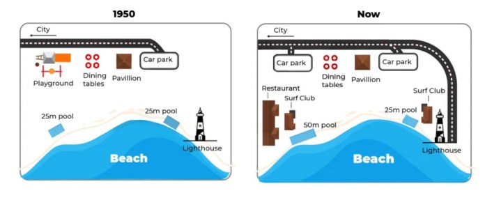
The maps illustrate the transformation of an Australian beachfront area between 1950 and the present.
Overall, the site has evolved from a simple recreational space into a more developed precinct featuring expanded facilities. It is also important to highlight that the access road along the northern edge has been widened from a single‐lane to a dual carriageway.
In 1950, visitors entered via a road at the , which led directly to one car park at the eastern end. Immediately below, a central pavilion stood flanked on its left by several dining tables, while a children’s playground occupied the far west corner. Along the shoreline, two identical were positioned: and the other adjacent to the lighthouse on the eastern tip.
Today, the upgraded dual carriageway provides access to two car parks—one at each end of the site. On the western side, the former playground has been replaced by three restaurant blocks. The pavilion and dining tables remain centrally located, and to their east a new surf club sits beside the lighthouse. Leisure offerings have also increased, with a larger installed to the west of the pavilion while the original 25 metre pool persists to the east.