
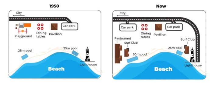
The maps illustrate the transformation of a beachfront area in Australia from 1950 to the present day.
Overall , the area has undergone significant redevelopment , shifting from a primarily recreational space to a more commercialized zone with improved infrastructure. The most notable changes include the expansion of parking facilities, the lengthening of the road, and the addition of new amenities for visitors.
In the northern section, the playground that existed in 1950 has been demolished and replaced by a new car park. The original car park in the north-east corner has also been expanded in size . While the pavilion and picnic tables remain in their original central location , the road has been significantly extended, now stretching further south along the eastern coastline.
Moving to the southern part of the map, the 25m pool on the western side has been enlarged into a 50m pool. Next to this facility, a new restaurant and a surf club have been constructed . On the eastern side, the 25m pool and the lighthouse remain unchanged ; however, a second surf club was built adjacent to the pool. The newly extended road now curves around this surf club, providing better access to the southern end of the beach.