
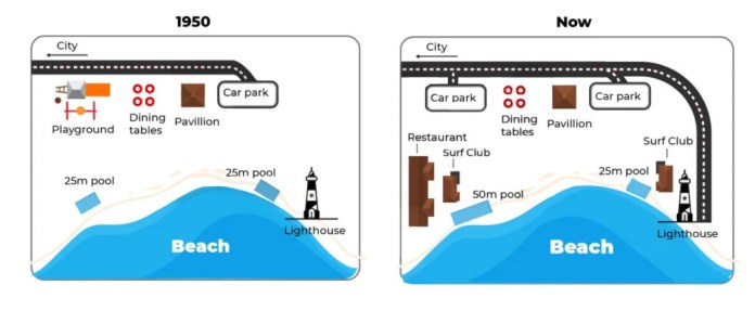
The given maps illustrate the transformation of a beachfront area of Australia from 1950 until now.
Overall, the area underwent significant changes and developments, both in terms of infrastructure and roadways.
In 1950, near the top of the map, there were a playground, dining tables, situated in proximity to one another, and it can be noticed that they are all . Moving southeast, a lighthouse adjacent to the sea, offering a panoramic view of the ocean. Finally, there were two identical pools located quite a distance from each other, although they were both next to the beach.
The present map shows a quite different picture of the area in which the road now has been extended in a clockwise direction , then ends at the unchanged lighthouse. Besides that, the previous playground near the road was also to make room for a new car park. A restaurant and a surf club have been put up right next to the southwest pool, which has also been from 25 to 50 meters. Meanwhile, the 25-meter pool near the lighthouse is still there, quite close to another newly built surf club.