
雅思A类小作文题型
地图
描述位置、发展和空间上的变化。
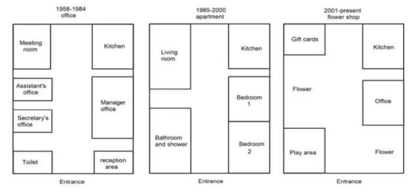
建筑底层平面布局的变化
Ground Floor Layout Changes Over TimeThe plans below show how the ground floor of a particular building has changed over time. Summarise the information by selecting and reporting the main features, and make comparisons where relevant.
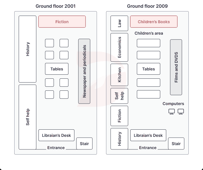
图书馆一层2001年与2009年改造对比
Library Ground Floor Redevelopment 2001 and 2009The plans show the ground floor of the library in 2001 and how it was redeveloped in 2009. Summarise the information by selecting and reporting the main features, and make comparisons where relevant.
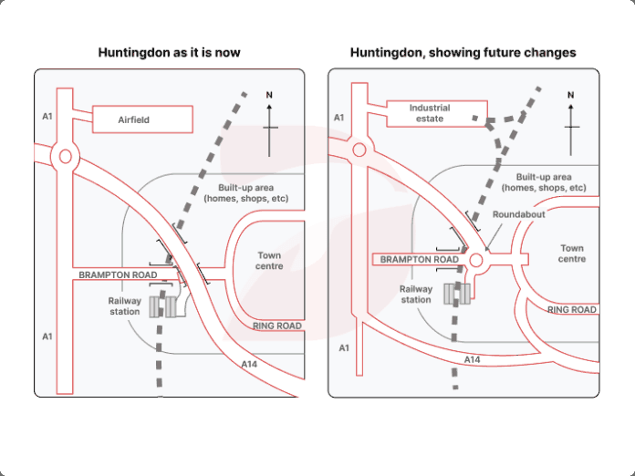
Huntingdon 现状与未来规划图
Huntingdon Present and Future MapsThe maps below show Huntingdon as it is now, and how it will change in the future. Summarise the information by selecting and reporting the main features, and make comparisons where relevant.
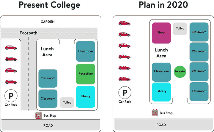
学院校区现状与未来改建规划
Present and Future College Site PlansThe diagrams below show the present building of a college and the plan for changes to the college site in the future. Summarise the information by selecting and reporting the main features, and make comparisons where relevant.
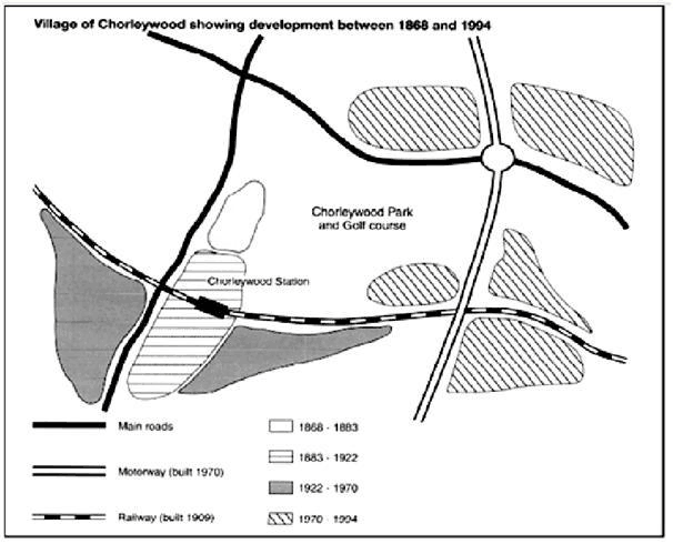
Chorleywood 村的发展
Development of Chorleywood Village Between 1868 and 1994Chorleywood is a village near London whose population has increased steadily since the middle of the nineteenth century. The map below shows the development of the village. Summarise the information by selecting and reporting the main features, and make comparisons where relevant.
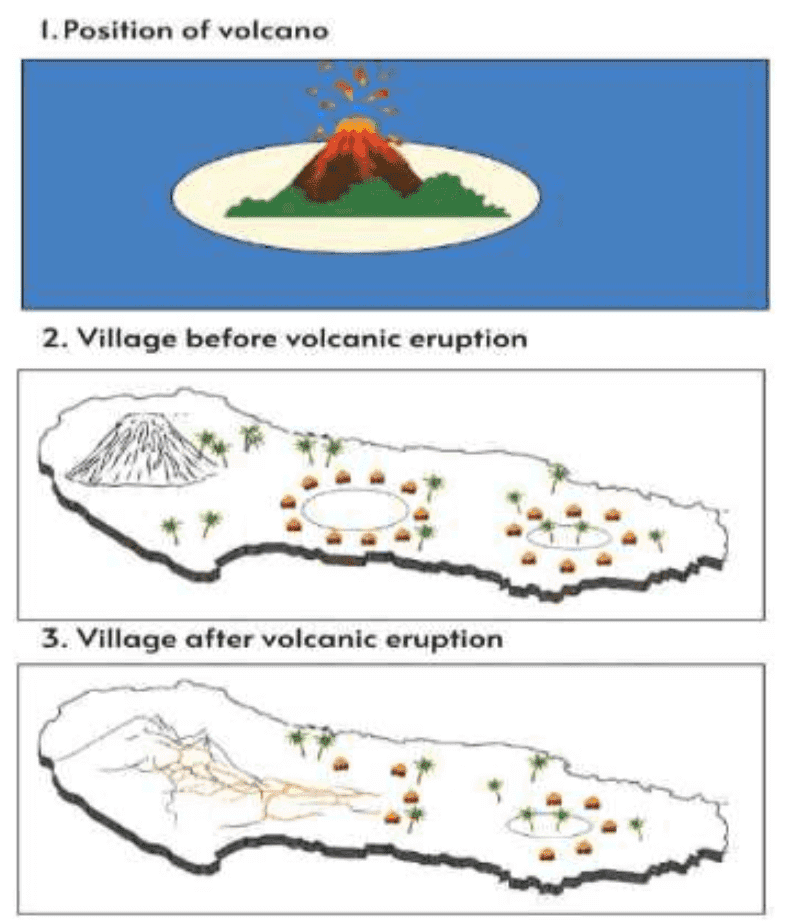
火山位置及喷发前后的村庄
Volcano Position and Village Before and After EruptionThe three pictures show the position of a volcano, and a village before and after volcanic eruption. Summarise the information by selecting and reporting the main features, and make comparisons where relevant.
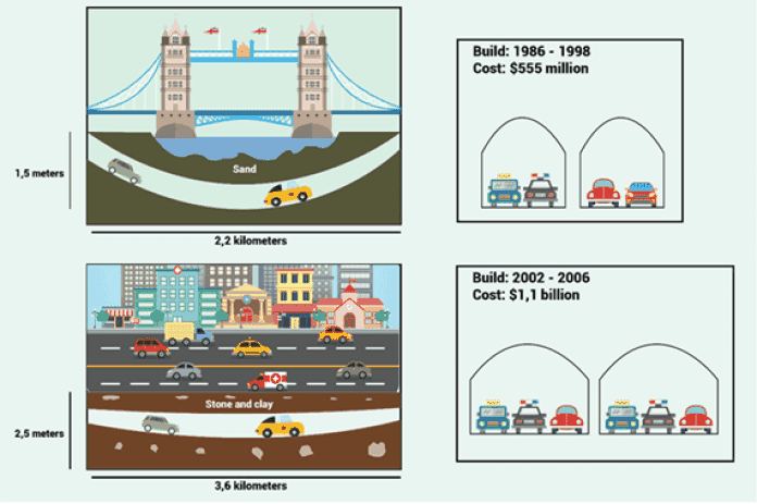
澳大利亚的两条公路隧道
Two Road Tunnels in AustraliaThe diagrams below give information about two road tunnels in two Australian cities. Summarise the information by selecting and reporting the main features, and make comparisons where relevant.
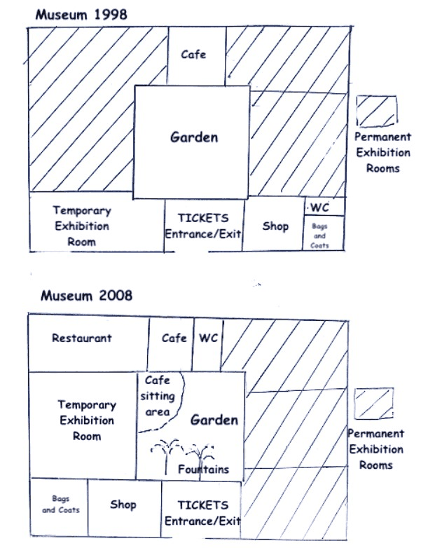
1998年与2008年博物馆平面图
Museum Floor Plan in 1998 and 2008The picture below shows the museum’s plant in 1998 and after some changes were made in 2008. Summarise the information by selecting and reporting the main features, and make comparisons where relevant.
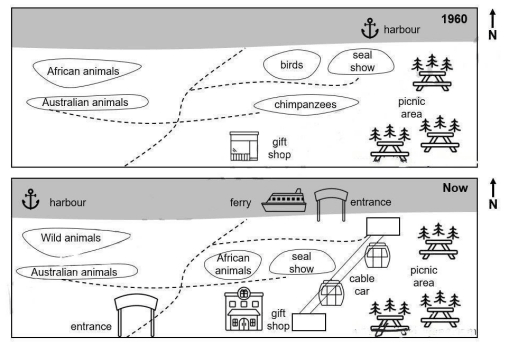
澳大利亚一座动物园自1960年以来的变化
Changes at an Australian Zoo Between 1960 and NowThe maps show the changes that have taken place at an Australian Zoo between 1960 and now. Summarise the information by selecting and reporting the main features, and make comparisons where relevant.
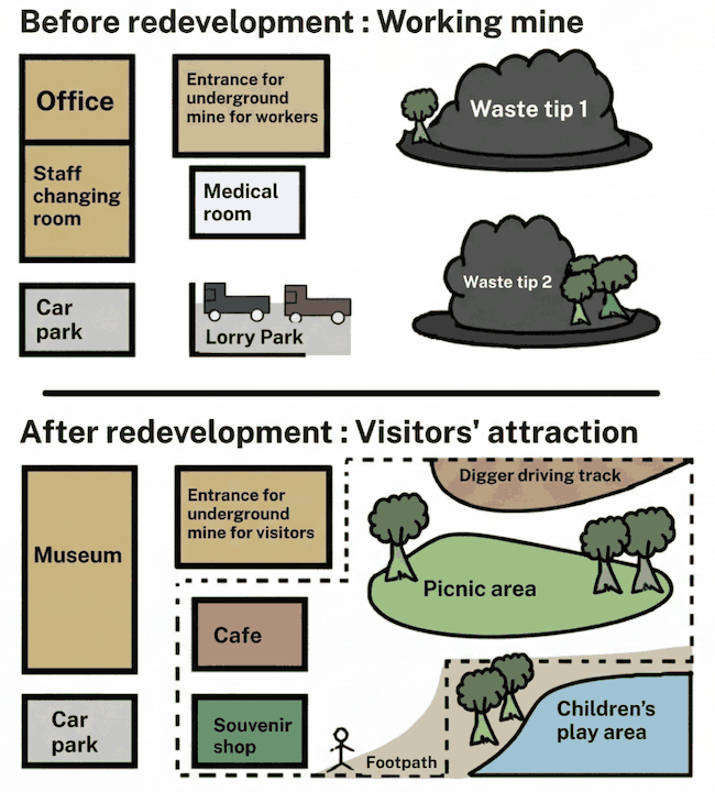
煤矿区重新开发前后对比
Coal Mining Site Before and After RedevelopmentThe maps below show a coal mining site before and after redevelopment. Summarise the information by selecting and reporting the main features, and make comparisons where relevant.
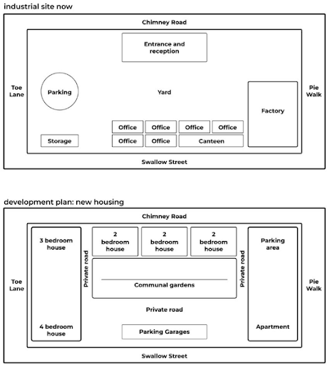
工业用地改造规划
Plan to Redevelop an Industrial SiteThe maps below give information about a plan to redevelop an industrial site. Summarise the information by selecting and reporting the main features, and make comparisons where relevant.
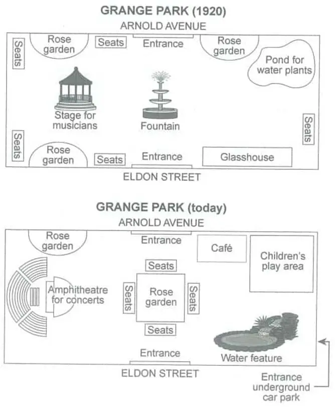
Grange Park 1920年与今天的平面图
Grange Park Plans in 1920 and TodayThe plans below show a public park when it first opened in 1920 and the same park today. Summarise the information by selecting and reporting the main features, and make comparisons where relevant.
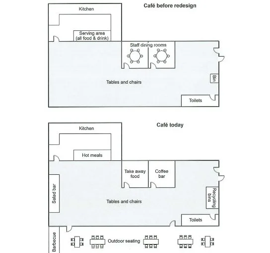
学院咖啡厅改造前后的平面图
College Café Redesign Plans Before and NowThe plans below show a college café before it was redesigned and how it looks now. Summarise the information by selecting and reporting the main features, and make comparisons where relevant.
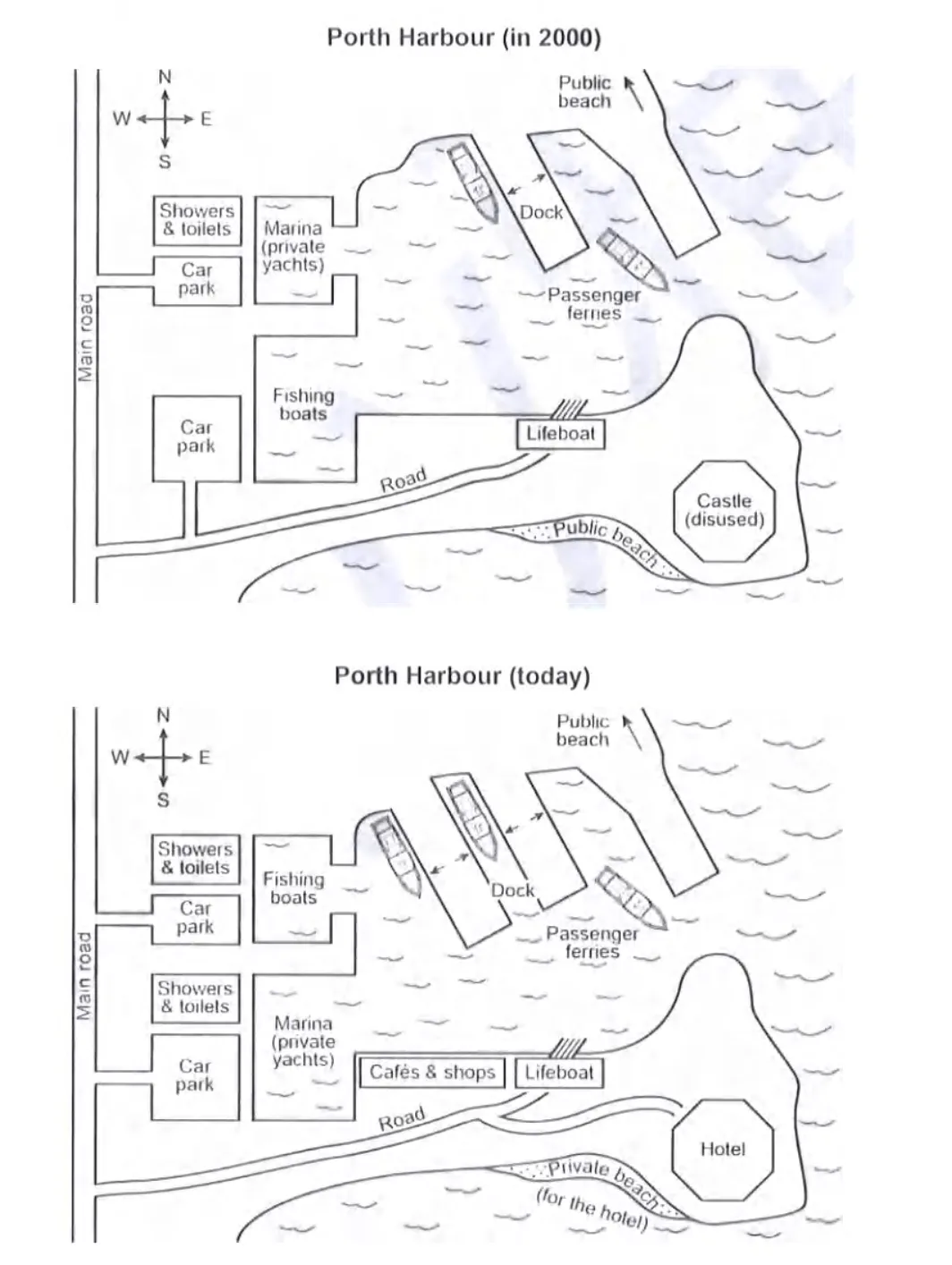
Porth 港口2000年与现今平面图对比
Porth Harbour in 2000 and Today MapThe plans below show a harbour in 2000 and how it looks today. Summarise the information by selecting and reporting the main features, and make comparisons where relevant.
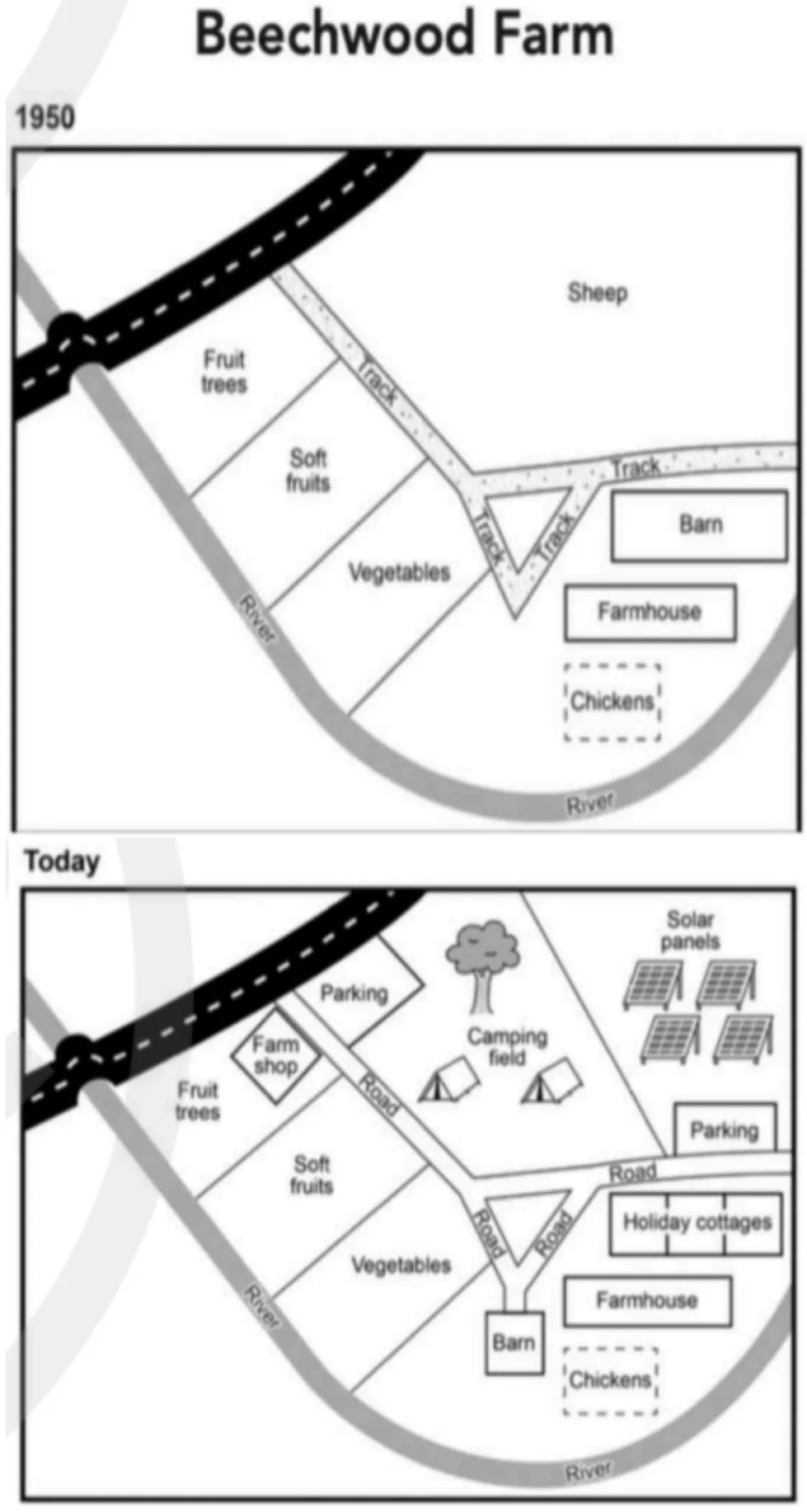
Beechwood 农场1950年至今的变化
Beechwood Farm Site Changes from 1950 to TodayThe plans below show the site of a farm in 1950 and the same site today. Summarise the information by selecting and reporting the main features, and make comparisons where relevant.
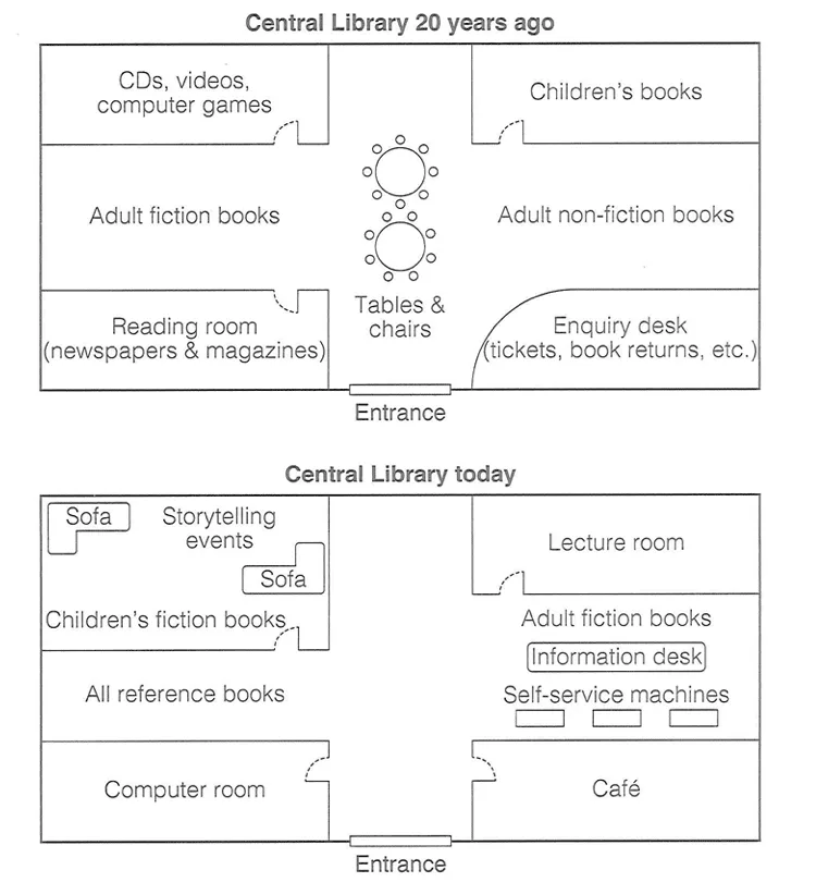
中心图书馆20年来的平面布局变化
Central Library Floor Plan Changes Over 20 YearsThe diagram below shows the floor plan of a public library 20 years ago and how it looks now. Summarise the information by selecting and reporting the main features, and make comparisons where relevant.
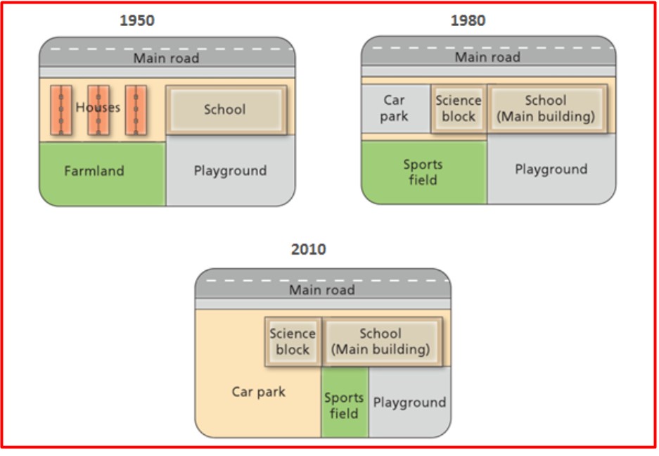
West Park 中学自1950年以来的变化
Changes at West Park Secondary School Since 1950The diagrams below show the changes that have taken place at west park Secondary school since its construction in 1950.
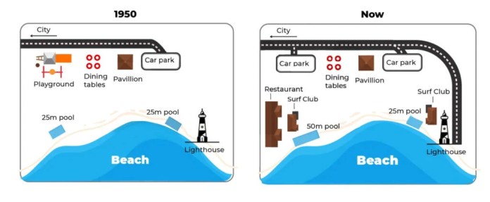
澳大利亚海滨地区1950年与今天的地图
Australian Beachfront Area Maps 1950 and TodayThe maps below show a beachfront area in Australia in 1950 and the same area today.
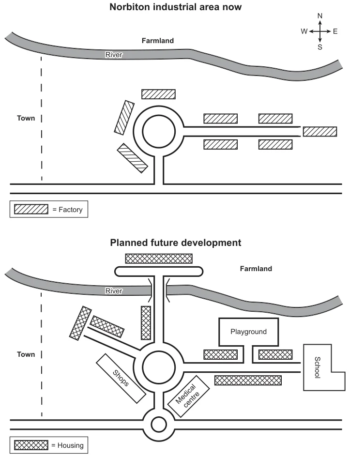
Norbiton 工业区重建规划地图
Norbiton Industrial Area Redevelopment MapsThe maps below show an industrial area in the town of Norbiton, and planned future development of the site. Summarise the information by selecting and reporting the main features, and make comparisons where relevant.
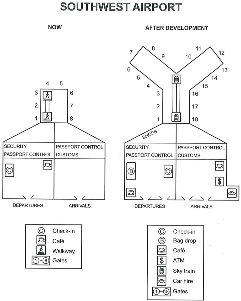
西南机场改建规划
Southwest Airport Redevelopment PlansThe plans below show the site of an airport now and how it will look after redevelopment next year. Summarise the information by selecting and reporting the main features, and make comparisons where relevant.
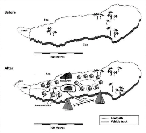
岛屿旅游设施建设前后对比图
Island Tourist Facilities Before and After Development MapThe two maps below show an island, before and after the construction of some tourist facilities. Summarise the information by selecting and reporting the main features and make comparisons where relevant.